
Seminole Springs Mobilehome Park Inc. (SSMHP) and the surrounding area of Cornell has a rich and storied history. Through the decades of homesteading and subdividing, ranching and drilling for oil, operating a mineral bath retreat and managing the land in a way that preserves its natural beauty, SSMHP has come to be a unique and special place. It is noteworthy that in July of 1986, residents purchased the park by forming a non-profit mutual benefit corporation that continues to this day.
The information below is based on the knowledge and research of several SSMHP residents. While efforts have been made to ensure accuracy, the information does not necessarily represent the opinions or policies of Seminole Springs Mobilehome Park Inc.
La Sierra Canyon - Cornell Area (1802 - 1905)
Written history about La Sierra Canyon begins with the Rancho Santa Gertrudis de las Virgenes concession of 1802. This was granted provisionally by then California Governor Jose Joaquin de Arrillaga to Miguel Ortega. The southern boundary was along Triunfo Canyon. Rugged areas like that of La Sierra Canyon generally were avoided in the acquisition of the concessions under both Spanish and Mexican rule unless they included important waterways. As originally defined, Rancho Las Virgenes reportedly included 17,760 acres. Interestingly enough, in the same year a concession known as the Rancho Topanga-Malibu Sequit including - again as later defined - 13,300 acres, was granted to Jose Bartolome Tapia.
Concessions granted under Spanish and Mexican rule concerned the use of land for ranching activities - particularly the running of cattle - with minor farming, and for missions supporting a desire to advance Catholicism.
The Rancho included a section of Triunfo Canyon at the base of the Santa Monica Mountains to which La Sierra Canyon is a tributary. Development of the land did not begin until the Treaty of Guadalupe Hidalgo made homesteading possible in the area.
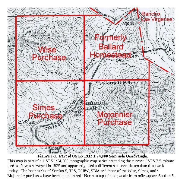
Two homesteads in La Sierra Canyon, one of John Ballard and the other of his daughter, Alice, were certified in 1901. Various private holdings in La Sierra Canyon today stem partly from selling off parcels divided from those homesteaded lands, and partly from parcels divided from the NW/4, the SW/4 and the SE/4 of Section 5 purchased from the federal government.
Residential development increased around 1906, when John Ballard died and his estate, descending to his heirs became available for subdivision.
Early Cornell (1906 - 1925)
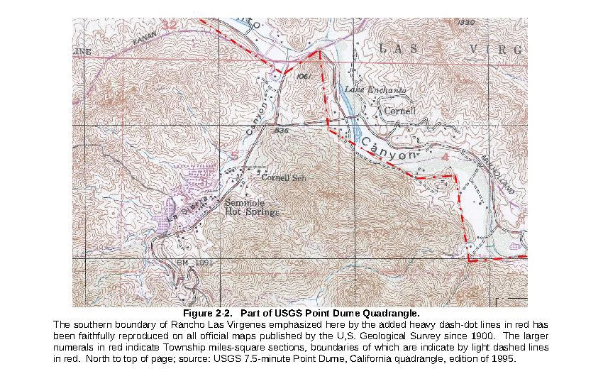
Since Mulholland Highway had not yet been constructed, Cornell Road was the main roadway in La Sierra Canyon. Cornell Road traversed from where Kanan and US 101 now meet (which was then Ventura Boulevard at the Malibu Junction) southward along Medea Creek to Malibu Lake. From there, Cornell Road followed Triunfo Canyon upstream to La Sierra Canyon, and then up La Sierra Canyon to end south of the mountain crest near Saddle Rock. At that point, the road connected to Latigo Canyon Road. Presently, Cornell Road ends where it meets Mulholland Highway near Malibu Lake at what is now Lakeview Drive. Originally, Cornell Road passed through La Sierra Canyon to the mountain crest where it met Latigo Canyon Road leading down to the coast. Thus, La Sierra Canyon provided the only local route from U.S. 101 to what then was State Highway 1, and is now the Pacific Coast Highway.
In the early days, La Sierra Canyon (named for its rugged skyline) was used primarily as ranchland. A school was located at the mouth of La Sierra Canyon where Sierra Creek is confluent with the creek that comes out of Triunfo Canyon; close to what is now the Rustic Canyon Store & Grill. The store structure may have been part of this early school.
According to an LA Times article, Norman Wise founded and named the town of Cornell in 1911, after Cornell University. "Wise founded the town… immediately after an artesian well of hot mineral water was struck on the property of the Ramera Oil Company." (Los Angeles Times - December 30, 1913) At the time there were approximately forty families living in the area.
According records of the Bureau of Land Management, other significant land purchases of this time also include:
Nathan Wise, April 24, 1916, Northwest Quarter of Section 5, Patent No. 526145.
William Simes, September 18, 1917, Southwest Quarter of Section 5, Patent No. 600761.
Elmer F. Mojonnier, November 16, 1921, Southeast Quarter of Section 5, Patent No. 832585.
Figure 2-3 illustrates their locations.
Oil had been discovered in 1875 in the nearby Santa Paula area in Ventura County. Some thirteen oil fields had been established in California by 1906. Therefore, a wildcat well - a well prospect in an area not known to produce oil -might have seemed reasonable in La Sierra Canyon.
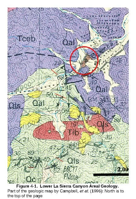
The drilling site in La Sierra Canyon was selected apparently for the purpose of exploring a section of what has been most recently defined by Yerkes and Campbell (1979) as the Topanga Canyon Formation, a marine formation of middle Miocene age that is exposed farther up La Sierra Canyon from the Park. Locally, it has been mapped by Campbell, et al. (1996) (see Figure 4-1). The boring, now the Park's hot spring well, is adjacent to Blackfoot Drive which, like the rest of the Park area, is underlain by a section of the Miocene Conejo Volcanic.
The reason the prospect was located in an area of volcanic rock - known even then to be non-oil bearing - is uncertain. The intent probably was to drill through the volcanics and into the underlying Miocene section from a site simply more accessible for a drilling machine. The thought may have been that the volcanics could cap oil traps in the Miocene strata. Nevertheless, it was a wildcat play, i.e., an exploratory boring in an area not known for producing oil. The boring either did not encounter petroleum-bearing beds, or if it did, that did not have showings sufficiently encouraging to drill deeper. On the other hand, the volcanic section may have presented drilling conditions so difficult that it was never penetrated. As a result, the boring would simply have been abandoned without reaching the Topanga Canyon section.
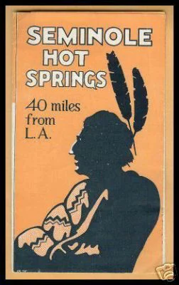
The Ramera Oil Company local prospect would have been drilled in 1911, if the Times article is accurate. According to the article, it encountered groundwater under artesian pressure, at a depth of "... over 2,600 feet...," that had a temperature of "116 degrees..." The water was then, as now, charged with hydrogen sulfide gas. From this condition, and by a play on the word "oil" and the name, Simes, the area became known as Seminole Hot Springs, which later inspired naming Park streets after various Native American tribes.
The community of Cornell, as conceived by Nathan Wise, was geographically rather amorphous, and it remains so. Were there to be a consensus on the matter, its boundaries might include the confluence of Sierra Creek and Triunfo Creek, Troutdale, new Cornell with The Old Place and neighboring residential developments perhaps as far east as Lake Enchanto once extended, but not so far as Malibu Lake and - upstream in La Sierra Canyon - the Rock Store, SSMHP, and arguably a bit farther to reach the vicinity of Alice Ballard's homestead, and possibly in that area, at least some privately developed landholdings.
Cornell Gravitates North (ca. 1925 - 1958)
What is currently the Old Place was once Hanks Country Store and Cornell Post Office. Cornell has been seen all over the world on the silver screen in many films; most notably in the 1931 classic Frankenstein, with the famous scene shot at Malibou Lake. Cornell became a popular destination for locals and tourists to enjoy nature and attractions such as Lake Enchanto (now Peter Strauss Ranch) and Seminole Hot Springs. Long before Agoura existed, the Cornell township hummed along in the Santa Monica Mountains. Many expected Cornell to become a bustling boom town, but without the discovery of oil, this did not happen. Even with two popular recreation destinations (Lake Enchanto & Seminole Hot Springs), Cornell remained a quiet gem, hidden away from the hustle of the city. Though isolated, it maintained a small business community; serving the Los Angeles-Ventura Highway in an area called “Cornell Corners" (where Cornell Road meets the 101 Freeway today).
Early Cornell, situated in La Sierra Canyon, was limited in terms of development by steep topography and a limited water supply. That it was controlled by just a few owners also may have been significant in this regard. In any event, by about 1925, with the completion of Cornell Road, and the marketing of subdivided parcels of Rancho Las Virgenes land by Machado's successors in interest, a move to nearby Triunfo Canyon - with its less rugged terrain and better ground-water supply - was logical. This left the Cornell School, the Mojonnier store and gas station, and Seminole Hot Springs Spa in - if not exactly splendid - at least comfortable semi-private isolation.
The seminal event that made further residential development possible was the establishment of the Las Virgenes Municipal Water District (LVMWD) in 1958. The LVMWD assured an adequate domestic water supply, and it was followed by construction of the Tapia Water Treatment facility in 1965, which eliminated the necessity of local cesspools and/or septic systems. According to the LVMWD web site, in July of 1965 "... the first drop of water was pumped to the Agoura Fire Station on Cornell Road." That, together with a joint powers agreement with the Tapia Sanitation District, served to increase the values of local properties significantly.
Seminole Springs Spa Days (ca. 1917 - ca. 1945)
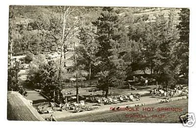
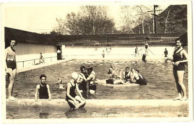
William Simes was the first private owner of the SW/4 of Section 5 and hence all of the land of the present Seminole Springs Mobile Home Park (SSMHP); including the site of the wildcat oil prospect. Apparently, the northern boundary of the Park (Navaho Drive) coincides with the common boundary of the SW/4 and the NW/4 of Section 5. More of moment, some exchange of title, as yet unclear, must have passed from Simes to Ward, or Simes to Baldwin and Ward, and finally to Ward, presumably as sole owner of the entire SW/4 of Section 5. It was most likely Ward who first installed hot tubs and built cabins - an enterprise that by 1921 had developed into a "... full-blown spa pulling over 1,000 people on an average busy weekend..." In addition, it was around this time that the Malibou Lake Mountain Club was being formed, and the Crags Club farther downstream in what is now Malibu Creek State Park - was also very active.
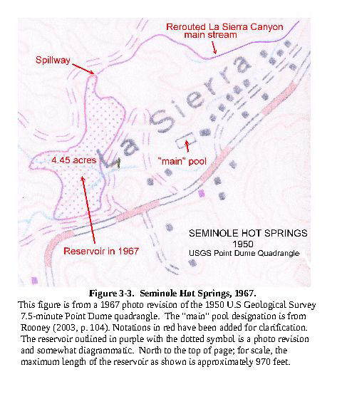
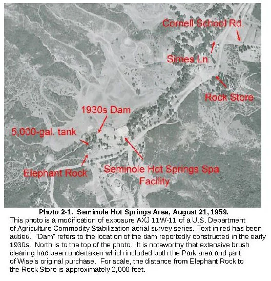
The popularity of Seminole Hot Springs Spa was enough motivation for Ward to construct a dam as part of the Spa's facilities. According to Rooney (op. cit., p. 100), the Spa's hot water was stored in a 100,000-gallon underground storage tank. Most likely, the dam was intended to collect stream water to supplement a potable supply for the Spa. Aside from the wildcat oil prospect, there were two other wells on the Spa property. The location of one, now abandoned, is in the community garden and RV parking lot, opposite the Park's main entrance where the upper edge of an 8-inch diameter steel casing is exposed. The location of the other well is undetermined. It may have been somewhere along what is now Apache Drive - close to what originally was the Spa's main drag. Production from the Spa's water wells apparently was stored in a 5,000-gallon corrugated metal tank. That tank remains today, empty and kind of forlorn, perched on the slope below Elephant Rock on its northern side, as indicated in Photo 2-1.
The Seminole Hot Spring Spa facility still existed in 1959, although then it probably was not operative. More relevant to development of the Park, however, is the fact that it shows extensive clearing of the slope where the Park now is located had been accomplished by August of that year. This suggests that by then the Ward interests had sold - probably to the developer believed to have been a consortium that included the Seminole Development Company and the Northwestern National Life Insurance Company. Assuming this is the case, actual grading for the Park may have begun as early as 1960.
Blessed by the LVMWD and Tapia facilities, older Cornell in La Sierra Canyon, and newer Cornell in Triunfo Canyon culled from Rancho Las Virgenes lands, have emerged, chrysalis-like from the rudeness of their past, as an upscale residential community. Protected from commercial encroachment on all sides by dedicated public lands as well as steep topography, the La Sierra Canyon - Cornell area has taken on the ambience of a retreat. For character, it has the Rock Store and The Old Place with their recognized historical character, now transformed to something approaching boutique equivalents, together with Troutdale, the local school house/ Rustic Canyon Store & Grill, and remnants of the Lake Enchanto facility, lesser lights perhaps, but still with their antecedent place in the local history. And most recently, as complement to the treasured rusticity of the Old Place, there is the Cornell Winery Tasting Room and Charme D'Antan - an establishment specializing in antique landscaping decor - entrepreneurial late-comers to be sure - but each with dedicated single-minded excellence that seems quite fitting with the independent character of historic Cornell. In addition, nearby, mountainsides once supporting only dense chaparral now present vast orderly rows of grapevines - a sophisticated transformation indeed. With recent drought conditions, the number of permitted wineries is under close watch by local government. All in all, Cornell seems to have achieved a mature stability safe from any radical future development. With unique communities of Malibou Lake, Seminole Springs, homes along Mulholland Hwy, and Cornell Road, it is clear that Cornell is a special place. In addition, surrounding landmarks like Paramount Ranch, Malibu Creek State Park, the Rock Store, Ballard Mountain and local wineries add to its character and charm.
Seminole Springs Spa Days (ca. 1917 - ca. 1945)
Seminole Springs Spa Days (ca. 1917 - ca. 1945)
Seminole Hot Springs Company

Seminole Hot Springs Inc. C0165988
Seminole Hot Springs Country Club, Inc. C0240052
Seminole Hot Springs Inc. C0283852
Seminole Development Co.
Seminole Properties LTD.
Seminole Springs Associates
Seminole Enterprises
Seminole Springs Mobile Home Park (ca. 1960 - ca. 1987)
Seminole Hot Springs Mobile Home Park
Seminole Springs Mobile Home Park
Seminole Springs Mobilehome Park, Inc.
